Author

Brian Wilson - page 5

Brian Wilson has 49 articles published.

THE APEX DIARY OF JACK STOCKS

in Apex Mountain Resort/Okanagan by

APX 087 copy

December 9th, 1961 Penticton Herald

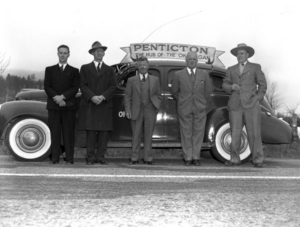
Explosive Apex Growth Could Make Penticton A Winter Mecca
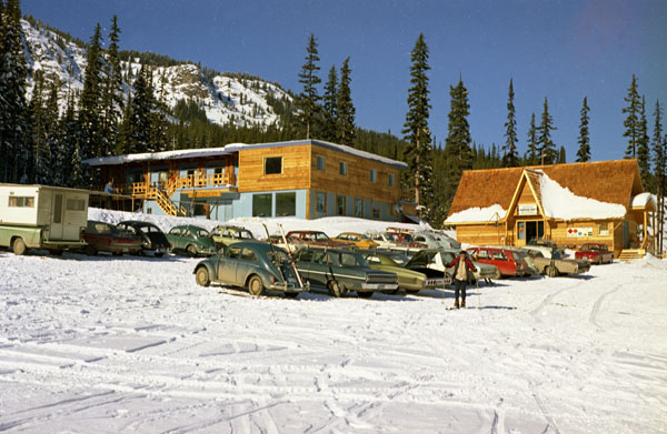
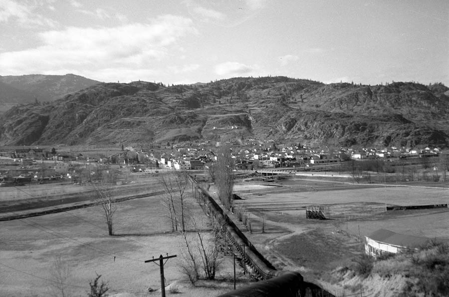
APEX LOGO COPYIn January 1959, after preliminary discussions on a personal basis, a meeting was called by H.R. McGregor and Jack Stocks and attended by J. Gibson, H. Donald, J. Dalrymple, Walter Powell, A. King, John Leir, P. Workman and Harley Hatfield. This meeting was called purely as a result of a decision to try and revitalize skiing in this area. It was recognized from the first that it was purely a round table discussion and two cardinal points had to be made by this group: Namely it was useless to make any attempt at revitalizing skiing unless adequate snow was available for a sufficient period. Because of this everything below a level of 3500’ in altitude was out of the question and therefore sites were sought which would provide this necessary depth and season. Secondly, the site had to have the proper accessibility.

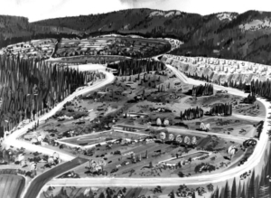
It was well known for the years since the end of the war, that a group of ardent skiers led by Jack Stocks and his senior Scouts had rendezvoused at Christmas and New Years for a camping and skiing holiday on Apex Mountain and its adjacent peak, Beaconsfield Mountain. This is an alpine area of between 6000’ and 7000’ altitude with snow from Dec. 1st to Easter. The first problem was therefore solved.

The problems of access were not easily solved as the current logging road to a timber reserve went through private property. After considerable negotiations it became necessary to purchase a large ranch which lay astride the proposed road site in order to gain a right-of-way through this area. This was done at considerable cost to the company (Apex Alpine Recreations Ltd.). However, the right-of-way was obtained and then the company resold the ranch to Orville Ray who proposed developing it into a Dude Ranch in summer and a winter skating and tobogganing site in winter.

In attempting to establish the area as a Provincial Park so as to obtain access to it for construction purposes without having to purchase land, a small difficulty was encountered. It was found that there were several mineral claims and a cabin belonging to Carroll Aikins of Naramata on the land in question. When the problem was explained to Mr. Aikins, he agreed to relinquish his claims so that the areas bounded by these could be incorporated into the new park. Mr. Aikins also agreed to relinquish his rights to the cabin on the stipulation that it should be at the exclusive disposal of the First Penticton Scout Troupe who for many years had used it for camping and skiing. The second problem was solved.

November 8th, 1964

Jack Stocks 1964
Jack Stocks 1964

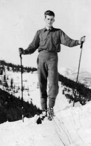
We were up at Apex cutting down a few trees at the top of Juniper near tower 8. It was a miserable day, snowing light, wet snow. We were burning, working in smoke with wet gloves etc.; you know, wet clothes. We climbed back up to tower 9, to the Jeep –  puff,  puff – tired.  Drove  down  to  the lodge tired and stiff, dirty as hell; but sort of exhilarated.

Outside the lodge was a great big Yankee car with a big, fat guy sitting inside all dressed up in a great big car coat with the windows shut tight, listening loudly to the football game while smoking a big cigar. Somebody peers in the window and asks about the game. The guy opens the window a crack, removes the cigar for the moment and says “Great game, the Lions are doing very well!” then closes the window. It just struck me as a perfect example of the typical North American sportsman – Gad!!

As to the road, the Government is spending approximately $30,000 on Green Mountain and Apex roads. They are completely renovating and widening from Boulder Creek down to Ray’s. They should be finished in about 10 days. The hairpin turn where the loggers lost their load is gone! A long culvert with huge fill installed. The logger’s short cut is now the new road and it eliminates three bad corners. At the same time they are working lower down at Allen Grove and the bridge where the road wanders around on the flat dotted with boulders has been staked and is straight as a die. At last, after all those years of saying “It wouldn’t take much”, finally they are doing it.

Ray’s Ranch Lodge is three quarters finished and looks real sharp. He has a huge stone  fireplace in  it, eleven  guest  rooms, a dining room and bar. Every two rooms share a bathroom with bath. Ralph West, the new owner, showed us the lodge on Friday. He’s a real neat, young guy; completely different from his predecessor. The concession in our lodge should be 100% better for it.

Apex lodge extension is about 90% completed. A propane power plant is now operating  in a  new  building  and the  new  septic tank has been installed.

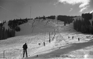
The T-Bar is 95% complete with the cable spliced and engine tested. They are installing the drops as well.

The new hill is groomed, almost to perfection. All previous reported piles of trees are either burned or buried, most in the creek at the bottom of the hill.

The second new hill makes a longer, less steep swing to the north and back to the Golden Zone road. It is now being cut out through light timber. The area at the bottom of the T-Bar is changed beyond recognition. It is opened up like a big bowl with new beginner hill running up to the lodge on one side and the T-Bar running up another side with the new hill running up farther over.

August 16th, 1968

The original Gun Barrell club house

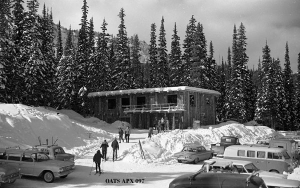
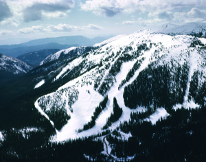
The Apex report on the expansion program for 1968: A $100,000 program is now underway. Included is a $51,000 Mueller T-Bar, 2400 feet in length. The top station of this lift is located at the bottom of the present intermediate (Juniper) hill, right near the start of the “Sissy” trail. It runs down from there to the sawmill site. A third bunny type run will connect the parking lot with the bottom terminal of the new lift.

Extensive clearing is being carried out in this new area. For this year, two major new runs will be opened – one immediately adjacent to the new lift, the other will swing out in an arc to the south of the lift and end up down at the mill site. This run will be approximately somewhere below the bottom of the “pit”.

The old T-Bar will be renovated and shortened to about 2400’. The large island of trees on the old T-Bar hill, between the lift and the main run, has been completely removed by bulldozer and changed the character of the hill. It is now very open and wide, and will now be more of an intermediate hill.

Other major improvements will include those to the lodge and the septic system.

An $11,000 Nodwell snowcat is to be purchased for snow grooming, lift maintenance, emergencies etc.

All this work is proceeding well on schedule. The lift line is all cleared and about half of the clearing of the new runs has been done. All the concrete foundations for the new lift have been poured. Unfortunately, just after this was done, Al Menzies came down with appendicitis and he is recovering from surgery. Al was supervising the crew that was doing all this work so I hope he will be well enough to resume this week. We are not contracting any of this out to save ourselves some money.

APX 096The Province has repaved the stretch between Kusler’s Ranch turnoff (the bridge) and Allen Grove. The pavement had broken up badly this past year due to poor conditions during the original paving. Also completed is the half mile or so through Allen Grove. So the road is now completely paved to Apex ranch.

In addition the Government is spending $10,000 on the Apex access road this year. Work to be done will include widening, blasting rock sections and blind corners above Shatford Creek; clearing the lower side of the right-of-way to facilitate widening and snow removal, ditching and gravelling. Ten thousand bucks doesn’t go far over 9 miles, but every little bit helps. If they spend that much every year; we’ll soon have a first rate road up there.

The Finances: The $100,000 required is being raised roughly as follows – $20,000 surplus from last year, $25,000 to be new capital raised by sale of shares and debentures. The balance of $55,000 is to be borrowed from the bank.

We are all very hopeful that this new hill will be a true intermediate ski area and attract the casual family skier.

October 3rd, 1968

Apex is going great guns. I was up there  today and there were two  big cats  working on one hill! What a difference to clearing by hand! The towers are all installed on the new lift and all that is left is to install the sheaves and string the cable. And man, you should see the road. For some unknown and amazing reason, the Provincial budget for the road has increased from $10,000 to $20,000! And they are doing a beautiful job.

November 8th, 1968

Last week I was in Vancouver helping Al Menzies man the Apex booth at the Vancouver Ski Fair in the PNE Showmart. It was the first one I had been to and was really great. Thousands of people went through which is quite amazing when you consider they each paid $1.75 just to get in! All the Pacific Northwest ski areas had booths, as well  as ski  shops, ski  companies, ski  boot companies, ski clothing manufacturers etc. They had a huge moving ski ramp which some of the hot shot skiers from the States demonstrated on short skis. Some of them even did flips! Al introduced me to Olympic Gold Medalist Stein Erikson which was a great thrill.

It won’t be long now before the new ski season is underway. They are already skiing at Mt. Baker and Whistler. Our expansion program at Apex is just about complete with the new lift just about ready to go. The Government has spent $30,000 on the road and what a difference. Apex has also bought the snowcat to groom and pack the runs. It can be used for maintenance and breakdowns as well.

January 9th, 1969

APX 087 copyOn December 29th it turned very cold and remained frigid until about January 1st. It was so cold up at Apex (about 40˚°below) that we had to shut down for five days, and as a result, lost about $5000 in ticket revenues that cannot be regained. After New Years Day, the skiing was quite good, although we could have used a bit more snow. Everybody seems very pleased with the new lift. It really is quite something. When you come barrelling down from the top of the Poma, down the intermediate only to discover another 2400’ of hill below yet to ski!

We had a lot of fresh snow this week, so I plan to go up tomorrow after lunch and cut some powder.

January 16th, 1969

Since the holidays, things have improved and we are now getting good crowds at Apex again. The new lift works beautifully and everybody thinks it’s great. I  bought myself a pair of Lange boots which I am gradually getting used to. At first they really hurt in front of the ankles.

The snowpack, I would say, is about normal or even a little below normal for this time of year. Apparently a lot of the snow we have been getting down in the valley is confined to the lower elevations. For example, when I left the house to go skiing on Sunday, there was about 5 inches of new snow outside. When I got to the mountain, there was only about two inches. However, the snow is settling nicely and the powder areas are getting good. I can ski the Pipe and the Tongue now without walking out as the connecting trails have been cut out to the new lift.

June 16th, 1969

And now some devastating news about Apex; last night we had our annual shareholders meeting and when it came to new business, a letter was read. It was an offer by five of the existing shareholders (Dawson, Betts, Sharp, Meiklejohn and Raitt) to purchase all the assets of the company! Well, what a bombshell! The offer was $10 a share, same as we paid originally, to be paid 50% in cash and the remaining 50% over the next two years with interest. It was brought to a vote and passed overwhelmingly to sell. There were 25 shareholders at the meeting and a number of proxies.

The whole thing happened so fast that it came as a shock to those of us who had nursed the project along from the onset. The whole thing seemed rather cold-blooded, especially as we were given no previous warning that such an offer was afoot.

The problem was that most of the shareholders seemed anxious to get their initial investment out as they had waited 8 years with no return. Another problem is that there seems to be no end to expansion and demand for more capital. It is increasingly difficult to get it from 50 shareholders, each of whom have a relatively small investment in the company. Another advantage to a smaller ownership group is that you can be damn sure they are going to devote a lot of time to the business to make sure it goes. There is some talk of Sharp becoming the new manager with Menzies reverting to the ski school. It’s the end of an era.

Feb. 3rd, 1970

APX 003 copyApex Alpine Recreations Ltd. has sold to five of the shareholders. It was a bit of a shock at the time, but it was probably for the best. Most of the original 50 shareholders were involved with a company that they weren’t spending full-time at and that made for some problems. Also it was always difficult getting ones ideas across (and I was president for several years) and trying to convince the board of directors.

Apex continues to improve and expand under the new ownership. I no longer have any involvement in the company.

Last year some major improvements were made to the lodge, including building overnight guest accommodation. This year a $100,000 chairlift replaced the original T-Bar, installed in 1964.

I am still skiing regularly.

Editors note: 

Jack’s contribution was never forgotten. His dedication to his Scout Troupe, Apex Alpine, the Downtown Business Association and to his craft as a photographer, knew no bounds.

Jack Passed away in 1979 after his best business year, ever. It was an untimely death to cancer.

Apex remembered him with the dedication of the “Stocks Triple Chair” in February of 1982.


A DEADLY DATE WITH THE HOPE SLIDE

in Fraser/Hope by

SLIDE 3 copyThe catastrophic event, commonly referred to as the Hope Slide occurred on Saturday morning, January 9th, 1965. There has been books and articles written on this geological event, enough to fill a bookcase. I would like to revisit this bit of history from the aspect of those killed in the slide. Forgive my literary licence.     

A Clear Road

Bernie Beck had just completed the mechanical alterations to his bright yellow ‘59 Chevy convertible. The new carburetor and the shaved manifold really increased the horsepower. Bernie loved this car; it was his mechanical trophy. Bernie had been working as a counter salesman for Westone Enterprises in Penticton. He was just 27.

His best friend Dennis Arlitt had been in the passenger seat of the convertible many times and was extremely jealous of Bernie’s car. He worked long hours at the Growers Co-op packing plant to try and save enough to get his own car. Dennis had a girl friend, Mary Kalmakoff, and they and Bernie’s wife, Shirley made up a close foursome. Dennis was 23 and Mary, 21. She had worked with Dennis packing fruit at the plant since she moved to Penticton in 1958. Mary had come from a very close ‘Sons of Freedom’ Doukhobor family and had been separated from her family when she was younger. Despite this, she was a vibrant and loving young woman who stayed close to her 5 other sisters. It was this feeling of family that directed Mary to ask Dennis if he could ask Bernie to drive them to see her sister Laura, in Agassiz. Bernie thought it would be great to give the car a workout and drive Mary to her sister’s place. After all he could never say no to a friend.
So after shift was over, Bernie picked up Dennis and Mary, and around 10:30 that evening they took to the highway.

Tom Starchuk hadn’t seen his wife Ann for more than an hour in weeks. He had been hauling hay to the coast continually since fall. The 38 year old trucker had just loaded fourteen tons of hay at the Glaicar Ranch at Grandview Flats near O’Keefe Ranch. Joe Glaicar invited him to lunch before leaving for the 10 hour haul to Cloverdale. By 2 PM, Tom was behind the wheel. Weather wasn’t all that good, so instead of his usual trip through the Fraser Canyon, Tom took the south route of Highway 97 to the Hope-Princeton. The load seemed to be riding evenly, but he stopped occasionally to check his straps and cables. He was pleased with this truck; not new but as of this season, it was all his.

Norman “Steph” Stephanishin pulled away from the Arrow Transfer yard in Kamloops with a full tank and pup of gasoline destined for Kelowna. His big yellow Kenworth purred softly as it sailed down Highway 1 to the Monte Lake turnoff. It would only be a couple of hours before he could unload then off to Vancouver empty.

Westward Bound

SLIDE 4 copyThere was a little more snow than expected, thought Steph as he climbed the hill toward Allison Pass. He saw lights in his mirrors so he politely signaled the car to pass. It was a nice bright yellow Chev convertible and the girl in passenger seat gave him a little wave. It quickly disappeared ahead of him. He had passed three semi trucks heading to Princeton but other than the yellow car, there was no other traffic.

Bernie was joking and laughing with Dennis to keep awake. Mary had crawled into the back seat to sleep a little, feeling weary after her long shift at the plant. The boys were pleased with the power of the car and it’s handling on the snowy, curves of the road. Bernie gave a little yell as the lights reflected off the snowbank ahead. What he thought was just a curve in the road was a huge wall of snow completely covering both lanes of the highway.

The Chev crumpled as they hit head on. The car jumped onto the slide and buried itself to the windshield. Bernie hurled forward onto the steering wheel and jammed his knees under the dash. Dennis hit his head as he slipped under the dash. Mary started screaming with the abrupt wakening of the collision. Bernie jumped out, in considerable pain and yelled, “Oh, no! My car, my car!” He crawled onto the crumpled hood to inspect the damage. “Not too bad.” he thought. “Dennis, help me get her out. Dennis and Mary seemed to have made it through the mishap unscathed. Bernie on the other hand, had really damaged his knees. He was limping badly. Mary said they should go back to Sumallo Lodge and get help. It was just a couple of miles back.

“I’m not leaving the car.” said Bernie, “I can get her out. Just help me dig around and get the back wheels on the road. Then she’ll drive out, I’m sure”
Mary turned to see lights coming down the highway toward them. She took off running to get help.

Steph had just geared down seeing the lights in the distance ahead of him. They seemed stopped in the middle of the road, so he was cautious. He pulled over as far as he could, stopped and got out. A young woman came running toward him and yelled “We need help! Can you help us?”

Steph reassured her that he would help. As he got closer he could see that it was the nice yellow Chev that had passed him a few miles back. A huge wall of snow about 30 feet high had closed the road in both directions. A young man limped toward him, “Please mister, do you have a shovel? I need to get my car out. It’s high-centred in the snow.”

“You look hurt, fella. You sure you’re OK?” asked Steph.
“Ya sure. Just need to get my car going.”
Steph could see another man at the car but the woman was shivering. “Come into the cab and get warm.” he said to Mary. She was more than cold, so she said “OK.”
Bernie introduced himself to Steph and took his shovel and hobbled to the car. Steph thought he should turn around and go back to Sumallo and get help, but with the pup attached there wouldn’t be enough room to get around. Just then a loaded hay truck came around the bend.

Tom had lots of time to slow when he saw the bright lights of the tanker truck ahead of him. The driver was walking slowly toward him with a bright hand lamp. He pulled the rig to the side about 100 feet from the other truck and got out as Steph approached.
“We have a slide ahead,” said Steph, “the road will be closed until Highways gets here.”
“Oh hell, I’m already six hours behind. Any place to turn around?”
“Not close,” replied Steph.
Tom went with the others to inspect the car. They took Bernie aside and explained there would be no way to get the car out. Bernie wouldn’t believe it and begged both drivers to put a line on the car and pull it out. Tom looked at Steph and they both looked up the mountain, then at the slide and said “no way”. Tom was exhausted so he excused himself. He would wait for help from Allison Pass highways crew at daylight. He crawled into his cab and went to sleep.

Steph tried to console Bernie about the car, but Bernie wouldn’t stop digging. Steph stated
he would walk to Sumallo and see if he could get a wrecker to come back and help. He was only a short distance down the road when a westbound Greyhound bus pulled up. Steph filled the driver in about the slide. The driver said “Get in,” and he backed down the road and turned about at the Allison Lumber Company road. From there it was just a few minutes to Sumallo Lodge.  Steph and the bus driver, Dave Hughes, found that the public phone was dead. The snow slide must have knocked out the line. Bob Sowden from the lodge couldn’t reach anyone on the radio phone either. After considerable conversation about the unusual closeness of the slide area to Lodge, Sowden got the drivers into his truck and raced to the site. As they arrived they could see that the two young men had not given up on the convertible. They were still digging.

Sowden told Bernie he would drive to Allison Pass, then bring his wrecker back to haul him out. He got back behind the wheel and headed back to Sumallo. Bob Sowden assumed he could get a front-end loader to the scene within a couple of hours.

Bernie and Dennis were exhausted and getting hypothermia. It would soon be light and they were still no closer to extricating the car. It was agreed to call it quits for now. As they walked toward the idling trucks, there was a vibration under their feet. They stopped and turned toward the mountain above them. They heard an ominous rumbling.
SLIDE 2 copy“We better get to the trucks, now!” screamed Dennis. “We’ve got to get out of here”.
They rushed to the hay truck to warn Tom, sleeping in the cab, just as the volume of rocks and trees hit the snow slide at tremendous speed and terrifying power. The car disappeared in an instant.
“Mister, run, run….slide!” screamed Bernie over the noise.
Tom jumped into the drivers seat and slammed the truck into gear to back down the road. Just then a sea of snow, mud and rock from the backlash wave bounced off the face of Mount Coulter and hit them straight on.

Dennis and Bernie just disappeared into the muck. The trucks rolled toward the oncoming rock slide and were crushed. Hay scattered the distance of the double wave while the cabs disintegrated. The empty tanks seemed to float for an instant as they sailed back up the peak. Then all went quiet.

Back at Sumallo Lodge, Steph and mail truck driver, Len Lloyd were concerned for the young people at the slide. They got into the mail truck and drove up the road. It was nearly 7am. They were only half a mile up the road when they came to another snow slide that had come down from the rock bluff adjacent. Steph had been right to warn the group about other slides. It was hoped that the trucks were just between the two slides.

SLIDE 3 copySteph would have climbed the slide toward the trucks until Len pointed out that there was a lot of rocks and trees in this slide. Not a wise move to try and hike over it. As light started to filter into the valley, the two men began to see a bit further up the valley. It became evident that this was not a snow slide. Coulter Mountain was bare of trees. Could the slide have come from there?

Then daylight hit Johnson Peak. The two men were speechless. No one could have survived this.

Steph’s heart sank as he thought of the four people he seemed to have just left moments before. He grieved for them as he thought of his good fortune to have escaped it. “Thank God,” he thought, “Thank God.”

AFTERMATH

Highways Minister Phil Gaglardi flew over the site soon after being notified and arranged for search and rescue at the site. By Sunday evening, both Beck and Starchuk’s bodies had been recovered. It was impossible to imagine where the other remains might be in the debris.
Gaglardi wanted the highway opened as soon as possible. When the Geologists had examined the slide site, construction began to push a road through. It took 21 days for a crude path to be pushed over the slide.
The rest, as they say, is history.

Sources:
Anderson, F. Hope Slide Story
Province, The Vancouver Jan. 11, 1965
Herald, The Penticton

WALKING THE WIRE

in Cariboo/Old Cariboo Trail by

CPM 032A copy

Suspension Bridges over the Fraser River

An Essay by Brian Wilson

I have always been fascinated by the methods gold-seekers to the Cariboo crossed the mighty Fraser River. This river is not a creek to ford; it’s a killer of a river that only the most foolish of men would try to cross without caution. The Royal Engineers under Governor Douglas were the enablers of crossings of the river to the goldfields. There were no fewer than three bridges built over the torrent between 1863 an 1868. Two still exist today.

DOG CREEK BRIDGE - Copy
Churn Creek Bridge

Part of the Port Douglas road to Lilloett became the Gang Ranch. The suspension bridge at Churn Creek (Dog Creek), built in 1863, is still used by the ranch today. The Alexandra bridge near Spuzzum is a heritage site next to the new Highway 1 bridge.

With the discovery of the Murchie collection of glass negatives came a chronicle of the building of another suspension bridge over the Fraser that few remember. It is the Chimney Creek Bridge near William’s Lake that became Highway 20 to Bella Coola. It was built by a pioneer of modern bridge building, Sam Smith. Not a lot is known of Sam Smith’s background. As he was a BC native and had a home in New Westminster at the turn of MURCHIE

Archibald Murchie at Princeton 1905

the century, it is assumed that he had worked on several other bridges, including the unusual cantilever bridge in the Fraser Canyon, the Cisco CPR railway bridge at Keefers.

This assumption is because Mr. Smith worked for Waddell and Hendrick, famed North American bridge builders and structural Engineers. As a matter of fact, Sam worked for the most famous of all suspension bridge designers, James A. L. Waddell of Kansas City (even in modern times Mr. Waddell is thought of as the Father of the Wonders of Engineering) and Waddell designed the Cisco bridge.

By 1901 the contract was set for Chimney Creek and the call for workers to build the 325 foot suspension bridge went out. It was to be a unique span with a lower counterweight to provide rigidity and overcome movement and ‘windlift’ common to suspension bridges. It was indeed, a handsome structure between graceful towers, an 80 foot Howe Truss on the east side and a 225 foot trestle approach to the west. Smith brought over 60 skilled workers in from across the country, including those who could feed and house them in the little village set up at the site.

waddell
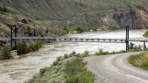
Now let’s put this project into perspective. The Provincial Government of the day led by Premier Edward Prior; was petitioned to build this bridge by a voting population of 40 white males, the total eligible voters of the Chilcotin. They insisted the bridge would bring prosperity to the entire heartland of the Province, and enable the production of cattle and sheep to feed the world.
The Premier was in fact, in the business of engineering and had a successful mining supply firm. With this background, how could he refuse them their bridge?

The site chosen was tenmiles down river from Chimney Creek, called “Sheep Creek” by the local ranchers. This was a good location for the bridge but extremely remote for the shipment of materials. Most of the supplies had to be unloaded at the Ashcroft railhead and hauled by wagon or sleigh many miles up the Cariboo Trail, then on through uncharted cattle tracts to the Fraser River. A young ranch hand named Henry Durrell, with more education than usual, took on the task of keeping the workers on

CTB 098A - Copy copy
Engineers Sam Smith and Henry Durrell

the site. Some who made the trek in, turned tail and left after seeing the difficult terrain at the crossing. Durrell made sure there was ample liquor and good food to reward the hard labour of those who remained.

Durrell acted as foreman to make continuous flow. He arranged drovers from as far away as Kamloops to join what looked like a convoy of 20 mule-team pack trains to haul the granite pier stones, weighing up to 450 pounds each, and the numbered prefabricated timbers to the site. It sometimes took two weeks to get to the bridge site and it was Henry that made sure they were placed without delay. But the story gets more interesting when the call goes out to supply the 700 foot, 2 ¾ inch suspension cables.

The good Premier Prior was also acting as the Minister of Lands and Works when the call to supply these cables went out to tender. When the bids came in, the Premier noticed that his Manager, of Prior & Co., had not bid. Perceiving a conflict-of-interest the Manager, in all honesty, could not bid; but the Premier did. As he had viewed the other bids, his bid was the lowest and his Company got the contract.

PRIOR
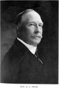
The Legislature was livid and called for his head, but Premier Prior wouldn’t resign. Prior’s gentry was his downfall as he stated he was privileged as a Militia Colonel
and previous Lieutenant Governor of the Province. He could do no wrong. Out of the turmoil stepped Lieutenant Governor, Sir Henry Joly de Lotbiniere and fired Premier Prior. The Government of the Province fell.

The bridge opened in 1904, but as time went on, the Bridge became a pariah for the locals. It squeaked and squawked and swayed; it spooked man and beast that used it. As automobiles became popular, no one was fool enough to drive onto it when anything else was on it. But it remained a valued part of the route to Bella Coola until it was replaced by a new bridge and blown to bits in 1962.

Sources:
The Road Runs West, Diana French 1994 – Harbour
BC Biographical 1914
Bridge Engineering, Waddell 1923
Murchie Collection of Photographs

THE ARROW LAKE SAGA

in Kootenay/Nakusp by
arrow lake

arrow lake
Part I

A couple of summers ago, I stopped at the Needles ferry for a picnic and walked along the shore of Arrow Lake. I was surprised with how little water there was in the lake. I could throw a stone across to Fauquier. I strolled down the steep bank to the waters edge and noticed a bright, oddly shaped stone. When I picked it up I was delighted to have retrieved a perfect arrowhead. The artifact was evidence of a passing native hunter; a man long gone from history. This was the start of my Arrow Lake Saga.

In 1953, the Sinixt People of the Upper Columbia River were declared extinct by the Canadian Government. This came as quite a surprise to the Native people still living on the Canadian side of the river basin. You might ask “why is this important to the powers that be in B.C.?” Well, that would simplify the movement to dam the Arrow Lakes.

CPAL 019The U.S. had been damming the Columbia since the 1930’s to control flooding and provide power to cities on the Lower Columbia. They constructed the Bonneville and Grand Coulee dams to also assist with navigation to their inland ports.

This all changed with the destruction of Vanport, Oregon during a flood in 1948. The city, the second largest in Oregon, was completely destroyed with the loss of 15 souls. Vanport was created after the First World War to provide jobs for veterans and their families. It was built on reclaimed river land and surrounded by high dikes.

As happens amongst governments dealing with international concerns, Canada and the U.S.A. decided to study the problem of this shared waterway. After studying for 11 years, the governments came up with a recommendation listing principles of how to negotiate an agreement to put dams on the Columbia. The appropriation of costs and benefits would be an ongoing issue of contention. Formal negotiations began in 1960 after twelve years of continued water problems. These negotiations were not about power (to begin with) but strictly about flood control. The undercurrent of the U.S. negotiators was always about the fact that power could not be generated efficiently without trans-boundary co-operation.

The Treaty was signed January 17th, 1961 by Prime Minister Diefenbaker and President Eisenhower. It was, however, postponed for three years due to the interference of the B.C. Premier, W.A.C. Bennett.

Premier Bennett stood fast with his “show me the money” attitude. His Social Credit Government was committed to the development of “public” power. He demanded funding for his “Two Rivers Policy”, and wanted the Columbia Treaty to include capital for his Peace River power project. He succeeded by passing Bill 5 that created B.C. Hydro as a public corporation. This corporation had no cash to finance these huge projects so Bennett succeeded in negotiating the Canadian Entitlement Fund with the Canadian Government pitching guarantees to the 274.8 million US fund and the U.S. contributing half of their power revenues and half of what the estimated cost of flood damage would be without the dam (64 million US) over 30 years.

Bennett completed both river projects in good time, but the construction and peripheral costs ran far more that the original benefit to the people of B.C. Future BC Governments would call it a shameful sellout.

Before the dams, the Arrow Lakes were a pristine highway between Revelstoke and the CPR mainline; and Castelgar and Minto Sternwheelerthe mines to the south. It was similar to Okanagan Lake in that settlements stayed mostly to the deltas of creeks and rivers along the route.

Transportation was provided by sternwheelers, eleven of them between 1888 and 1954; and five tugs between 1891 and 1954. As with Okanagan Lake, there were four CPR sternwheelers: the Minto, the Kootenay, the Rossland and the Bonnington. They plied the waters between Arrowhead in the north and Robson West to the south.

The big town on the lakes was Nakusp and this is where CPR decided to put the boat-building business. Nakusp was on the west end of the Slocan and was served by a CPR spur line to the mines of Sandon, New Denver and Silverton. Arrow Lake was dotted with small hamlets along the route, sparsely populated with mostly British colonialists looking for tranquility in an agrarian lifestyle.

Generations lived contently along the lakeshore, off the grid; paying little for self-sufficiency. Similar to the prairie grange, the various communities were close and concerned about the welfare of each other. It was a Walden-like existence that needed little policing. But all good things come to an end.

W.A.C. Bennett’s announcement of his dam project startled the citizens along the lake. He announced that the water would rise 12 metres. There were no plans for public hearings or any input from citizens groups. 2000 people were notified that they would be moved in short order. 3144 properties on Arrow Lake were to be expropriated. 39 properties were to go with the construction of the Duncan reservoir. Many more went with the Mica Dam survey. Bennett’s answer to protest was: “Come work on the dams!” and many did.

BC Hydro sent an army of surveyors and assessors to value the properties; many were sent packing by residents but returned soon after with peace officers to complete the job. Property was appraised without consideration for lifestyle and a wealth that cannot be appraised. Crops, livestock, lumber and even tourism were not considered. Moving a family to a new community where surroundings were unfamiliar, friends were gone and costs were higher; was to destroy a wonderful way of life.

Bennett put huge amounts of money into new communities at Burton, Fauquier and Edgewood where some hauled their homes to higher ground. But over the next four years the population dwindled. Citizens just couldn’t fight the BC Hydro legal machine so they took the money and left.

The hanMinto Sternwheelerdful of non-extinct Sinixt Nation members held little power with the signing of the water treaty and Indian Affairs refused to address any rehabilitation as there were no reserves or open claims. The timing was perfect and the Tribe lost their sacred sites, their burial grounds and their hunting grounds without so much as a nod. Most moved below the border south of the Libby dam.

One casualty of the rising waters was the fate of the S.S. Minto. The little sternwheeler was taken from service in 1954 and purchased by the town of Nakusp as a potential draw for tourists. However, the project floundered for lack of funding and leadership and she was sold in 1956 for scrap. Anything of value was removed but just before total demolition, John Nelson purchased her for $800 and towed her to Galena Bay at the north end of Upper Arrow Lake. He lived and worked on the boat to restore her, but his life ended at 88, ten years after beginning the restoration. BC Hydro assessed the restoration of the boat at over $100,000 so backed away and John’s son, Walter arranged to have the Minto pulled into the middle of the lake for
a Viking funeral. She was burned August 1, 1968.

The Minto was a symbol of life on Arrow Lakes that can never be reclaimed. It falls to memory and to organizations like the Arrow Lake Historical Society and OATS to keep the legends from fading.

The Keenlyside and Mica Dams now produce the majority of the electricity used by the interior of our province. The towns along Arrow Lake have the comforts of this utility like the rest of us and pay like the rest of us. The cost we don’t consider is to the environment, fisheries and paradise lost.

Part II

A year ago the cover story for Archivos was the Viking Funeral of the S.S. Minto. It was the last of the sternwheelers plying Arrow Lake until it was taken out of service in 1954. The part of the story I skimmed over was the efforts of John Nelson of Galena Bay to preserve the remnants of the ship for posterity.

What came to light was an amazing album of photos and notes from a good friend of John Nelson, Isabel Gordon. Isabel and her mother lived in Nakusp most of their lives and loved the Minto. The Nelsons and the Gordons travelled on many occasions together on roundtrips to and fro on the lake. Her photographic record of these trips is a treasure itself and stands as a comprehensive record of the last years of this amazing ship. I want to thank Arnold Talbot, a one-time crew member of the Minto, for finding, preserving and sharing Ms. Gordon’s album with us.

John and Agnes Nelson immigrated from the UK in the late 1900’s and took up farming on the lakeshore just south of Revelstoke at Galena Bay. They and their son Walter, and daughter Margaret, became dependant on the CPR service on the lake. That lake service was the three major sternwheel driven ships, the Bonnington, the Rossland and the Minto. It was much easier to travel to Nakusp to shop for the necessities than to take the train from Arrowhead or the road to Revelstoke.

That’s where they befriended the Widow Gordon and her daughter, Isabel. John became their handyman, helping with chores around their small property that only a man can do. This friendship remained strong for 30 years.

John Nelson loved the Minto. He was a regular on the ship through every season, he knew all aboard and all knew him. Like his ship, he was a fixture on the lake. He would not accept the reality that CPR was not going to continue service indefinitely. The eventuality of the scrapping of the ship and the end of an era came in 1954.

Minto SternwheelerAutomobiles and local ferries made the large boats expensive and obsolete. Tugs pushed barges from railhead to railhead north and south on Arrow Lakes. It was just evolution. The other ships had been dismantled many years previous and the Minto was in need of expensive upgrades. Captain Otto Estabrooks had been an admirable pilot and wanted to retire. After all, he had begun as Chief Engineer on the S.S. Okanagan in 1913; that’s nearly 40 years on a sternwheeler.

Nelson just couldn’t let his lady go and got very involved with the Arrow Lakes Historical Society in an attempt to have the ship declared a provincial heritage site. He was thrilled when the City of Nakusp purchased the vessel from CPR for a dollar as a potential tourist draw. Unfortunately the area was too poor and sparsely populated to seek the financing needed to restore her. After 2 years of attempts to gather funding from the community and government agencies, the Council of the day decided to sell the Minto for scrap. A Nelson scrap company purchased the ship and took every bit of brass and steel out of her (even removing the sternwheel) leaving her empty hulk on the lakeshore at Nakusp.

John stepped in and gave the company his savings of $800 for the rest of the ship. On July 12th, 1956, John’s son Walter towed the wreck using the tug Pentagon, to Galena Bay. She was pushed as close to shore as was possible and as close to the Nelson home as was possible. Then in February of 1957, John’s wife Agnes, died. John was devastated. Driven to complete his project, he moved on board and began repairs. The next season, the lake rose exceptionally high and enabled the Nelsons to drag the ship even further onto the shore. John was able to replace some of the window frames, flag pole and the name-plate but the rest was difficult for a man pushing eighty.

The Minto sat there on the beach for 10 years to the delight of many visitors who were allowed to wander on board and view John’s crude displays of her history. Each year he would throw a Christmas party for his friends and family where he would decorate and light the ship in a seasonal theme.

Minto SternwheelerWalter was a big help to his dad and assisted with the ongoing repairs while operating a successful boat rental and guiding business on the lake. Even when John got sick, he helped keep the farm and the ship going. But as all things come to an end, John passed away November 27th, 1967 from complications with pneumonia. He was in his 89th year.

Walter and other members of the Arrow Lake Historical Society pursued BC Hydro for funds to save the vessel but with time running out for the lakeshore with waters rising from the dam; BC Hydro backed out of the deal stating unrealistic costs to preserve an incomplete wreck. Walter had no choice but to haul it out to the middle of the lake and burn it. Even then she didn’t want to go and only burned the superstructure. The rest had to be scuttled.

It’s not known what happened to the Gordons. We assume that the rising waters affected them as well and they moved to a larger centre. Mr. Nelson’s contributions to Isabel Gordon’s scrapbook tells his story and that of the last of the sternwheelers.

SENATOR LYTTON SHATFORD AND THE BIG PIPE

in Okanagan/Oliver by

OLI 083 copy

The Story of the Creation of the Town of Oliver

Born in 1873 in Hubbards, Nova Scotia, Lytton Wilmot Shatford arrived in Vernon in 1893. He came to join his brother Walter who had established a dry-goods store in the downtown area of this north Okanagan city. Lytton had worked as a bookkeeper in Nova Scotia, so it was natural for him to assume that position with the store in Vernon.

OLI 038 copy
Golden Gate Hotel Fairview, 1915

The success of the northern store and the arrival of the CPR opened incredible opportunities for the Shatfords, and they soon had stores in Fairview, Hedley, Camp McKinney, Sandon, and the Slocan. The wealth generated from these mining camps was considerable.

It is noted that Lytton was Mayor of Vernon in 1898-99, and was a staunch supporter of the British Columbia   Conservatives.  He worked diligently to rise in the party ranks until he was elected as the Similkameen Member of Parliament in 1903.

With the brothers’ success (there were four – Lytton, Walter, Shelborne and Beckford), and with investment capital available, it was natural that they look for opportunities in the valley. Walter liked Hedley and was happy running the store there. Beckford became one of the first fruit orchardists in Penticton, and Shelborne was raising his family in Vernon. He sat on Vernon Council from 1914 to 1919, three years as Mayor.

SHATFORD
Senator Lytton Shatford

Lytton informed his brothers that he saw an opportunity in the Tom Ellis’ and Judge Haynes’ properties in the south. J.C. Haynes had passed away in 1888, and Tom Ellis had added his 21,000 acre ranch to his vast holdings. When Tom wanted to retire in the late 1890’s, he planned to market some of his property which reached from Naramata to the border, and was home to over 20,000 head of cattle. The only party interested in it all was the Shatford Brothers.

The Shatfords formed the South Okanagan Land Company in 1905, and made Tom Ellis an offer. They ended up paying Ellis $405,000 for most of the property. Tom did carve off a small chunk between the lakes for the townsite of Penticton before he happily retired to White Rock, where he lived in the lap of luxury until his death in 1918.

By 1907, the company had disposed of the Naramata/Cedar Creek section of their grazing lands to J.M Robinson for his townsite. There was rumour of railway surveys this year from both the US and Canada for the valley. They would be looking to purchase right-of-ways. Success just seemed to roll into the Shatford coffers.

Lytton liked the Fairview store and actually organized the local school, and sat as head of the school board. He accomplished this along with his services to the constituents as their MLA. From this office he was able to use his influence with the provincial government to secure water licences and easements through Native reserves for irrigation. The corporation understood that no subdivisions could be established without a continuous source of water.

By 1910, Lytton Shatford as our MLA, was also president of the British Columbia Life Assurance Company of Vancouver, vice-president of the Portland Cement Company in Princeton, president and managing director of the British Columbia Financial & Investment Company, director of the Bank of Vancouver, and in 1913 he was elected president of the B.C. Yukon Chamber of Mines. He was also a staunch Mason. It would have been impossible to refuse Mr. Shatford anything he proposed for the south Okanagan lands he and his company wanted to develop.

Lytton watched his businesses wind down with the declaration of war. Ranchers, construction workers and miners cleared out to join the Dominion forces fighting for King and Country. Even without this workforce, the Land Company continued work south of Okanagan Falls with the installation of an irrigation system at McIntyre Creek, just south of Vaseux Lake. But this installation did nothing to increase the interest in the subdivisions for sale in the area.

In 1917, Lytton Shatford was offered a Senate seat in the federal government of Robert Borden. The Similkameen seat went to William Alexander McKenzie, Mayor of Penticton.

As the war ended, our Senator became aware of the returning veterans and the difficulty they were having in procuring employment. Lytton was in need of a work force to complete the development of the Land Company holdings in the south Okanagan.  He met with the Premier of B.C., John Oliver and his Minister of Lands T.C. Patullo. Oliver was a convert, and he began campaigning to pass the Soldier’s Land Act in the Provincial Legislature. The Premier had no problem passing his bill in 1918 as many of the MLAs had sons returning from service.

What this Act of the Legislature enabled Pattulo to do, was to raise funds to purchase a parcel of land from Shatford and the Land Company. A deal was drawn up for the purchase of 22,000 acres of land from the border to Okanagan Falls, along the Okanagan River. The price was $350,000. In 1919, the South Okanagan Lands Project was launched.

OLI 157 copy
Early townsite with Canteen, General Store and Bank

Returning veterans were given special purchasing privileges for the land to be developed. They could work on the water system for $5 for a 10 hour day and chose a five or ten acre parcel for 10% down of the $1000 (five acre) or $1000 (ten acre). Price per acre was half for the bigger parcel. If they made the payments for 5 years they would receive a $500 rebate. Irrigation rates would be an additional $6 per acre per year. A hundred and fifty men came for the first contract.

The project engineer was another close friend of Lytton Shatfords. Frank Latimer had laid out several irrigation plans for the Land Company in Penticton and had remained in their employ for 12 years. He was appointed Head Project Engineer by the Oliver Government and stayed to completion.

OLI 177 copyThe first contract was given to retired Colonel A.E. Griffin of Vancouver. His company was to remove 250,000 cubic feet of dirt for the main ditch from McIntyre south. Work began in August 1919, during one of the hottest summers on record. Griffin employed the veterans as they walked off the train, as he had set up his office at the South Penticton KVR yards. They were shipped to a camp at the foot of Vaseux Lake or to the other camp further south below Fairview. Griffin brought in a mechanical shovel at McIntyre but work at Fairview was done with teams and scrapers.

Griffin received a second contract to line the ditches with concrete when tests of the porous soil proved that the base was unstable. This work held back the completion of the canal and cost a small fortune. The project was only 10 miles long by 1923 and would not be completed to the border until 1927.

OLI 185 copyThe complicated irrigation system was topped by the “Big Syphon”. Seven miles from the diversion dam, it was decided to build 2000 feet of stave pipe to bring water from the east to the west side of the valley. The pipe was six and a half feet in diameter and ran into 1600 feet of partially buried riveted steel pipe to bring water right into the townsite at considerable pressure. By 1926 a town was born. Of the 189 men who purchased farms from the program prior to 1926, all were still farming in the district by 1936.

The largest of the work camps, Camp #4, was the home to over 400 workers and was located near where the Oliver KVR Depot is today. Fondly called “Canteen” due to the company store at the site, it became the first permanent site for the town. Because the Premier had such an effect on the area’s development, the veterans chose the name “Oliver” to honour their benefactor ‘Honest’ John Oliver.

Unfortunately, Lytton Shatford did not see the completion of the subdivision of his irrigated lands in the south. He died at his desk November 8th, 1920.

PORTRAIT OF A PIT MINE – BRENDA

in Okanagan/Peachland by

BREN 001 copy
Morris M. Menzies, Vice President of Brenda Mines in 1970 asked, “Will it, as we are told by politicians, reporters and conservationists, despoil the countryside? Or will it be, as we affirm, an unqualified blessing to the people of this beautiful valley, the Province of British Columbia and the Canadian economy?”

The earliest record of the Brenda prospect appears in the Geological Survey of Canada Memoir No. 243, 1947. It was written by Dr. H. M. A. Rice following his field examination of the Copper King property above Peachland, in the summer of 1944. The Sandberg Brothers of Kelowna had for several years been working on a narrow quartz vein, well mineralized with copper pyrite and molybdenite, probably expecting to develop some tonnage of good grade gold and silver ore. Their claim was very near the centre of the the present Brenda pit mine. Work was stopped by the Sandbergs after Dr. Rice’s examination. The property was forgotten locally and the Survey’s report apparently failed to attract any wider attention.

Bob Bechtel, left, with Bern Brynelsen at the claim in 1955.

In the early 1950’s, Bob Bechtel, a Canadian Army veteran from Hamilton, Ontario, settled in Penticton. Bob, a mechanic by trade, made a living by working in local garages and driving a school bus. Life was pleasant for Bob, and he found his greatest satisfaction in prospecting the mountains of the Okanagan Valley. Having had no training in prospecting, he bought a Jeep and books on the subject and diligently applied himself to being a traditional prospector.
Fortunately, Bob did not know -or if he did, he ignored the fact -that no economic mineral deposit had ever been found in the Okanagan Valley. Mining companies could not be persuaded to invest time or money in an area of so little potential.

On a bright summer day in 1954, Bechtel drove his Jeep up the old irrigation road towards Brenda Lake. The old irrigation district wagon trail from Peachland followed Peachland Creek for 18 miles to the Copper King claim and continued on to its terminus at Brenda Lake and another 2 miles to the west. In this distance, it climbed 4,400 feet from lake level to 5,600 feet at Brenda Lake.

Bob had not heard of the showing from the Sandbergs, or the G.S.C. report. High-grade chalcopyrite-molybdenite ore on the old dumps was a spectacular sight but Bob knew then that there was not enough of it. The huge tonnage of lightly mineralized fractured rock must make profitable ore or there would be no mine at Brenda Lake. With an intuitive faith in his discovery, Bob staked his first claims a few days later and began his long vigil over the Brenda property.

BREN 007 copy

An artists conception of how the mine would look after the mine was worked out. It was planned to have the pit used for public recreation.

THE NORAND-KENNECOTT PROGRAMS

In the spring of 1955, Bechtel, having heard of the Noranda office in Vancouver, contacted the manager, Bern Brynelsen, and requested an examination of the Brenda property. Despite the low copper values obtained from Bob’s samples, Bern was never to lose interest in this intriguing prospect. Subsequent visits by Brynelsen and Morris Menzies, his assistant; led to an option agreement and plans for a program the next summer.

On April 17th, 1956 a party of 12 under Menzies’ direction drove to Brenda Lake and in 3 days, over 6 feet of packed snow, staked 80 claims around Bechtel’s key group. Three diamond drill holes were drilled that summer with the core returning an average copper value of 0.21 percent and partial assays indication about 0.03 percent molybdenum.

There was no established market for molybdenum and the copper content was far from ore grade, so it was not surprising when Noranda made known its intention to withdraw. Wishing to see further work done and attaching considerable importance to the presence of molybdenite, Brynelsen approached Kennecott, a major producer of that mineral in the United States, and proposed a joint program with Noranda the following year. This was approved and an agreement was signed that winter.

In June of 1957, Northwestern Explorations, Kennecott’s exploration company in British Columbia, began an aggressive program under the able direction of Engineer, Charlie Ney. In addition to claim surveying and the preparation of geology, fracture density and alteration maps (the first induced polarization program ever undertaken in B.C.), was run over the greater part of the present Brenda ore body. The only weak part of an otherwise excellent program was the pattern of X-ray holes, which were only 20 feet deep and showed considerable leaching. Ney suspected that, had the drill holes been 50 feet or more in depth, the mineral leaching would have shown successful value.

The winter of 1957-58 saw Noranda and Kennecott withdraw from the Brenda project and the property returned to Bob Bechtel. He requested and received help and advice from Brynelson and Menzies from that point onward.

THE YEARS OF WAITING

Bob ended up in a waiting period that was to last six years. There was no illusion of an early demand for Brenda’s low-grade rock but there was a determination to hold the property, if necessary, for fifty years. Data accumulated over two seasons of field work established, to the owners’ satisfaction, that Brenda had earned the right to an exhaustive test at an appropriate time determined by markets and advances in mining technology. Prospecting continued and two deep holes were drilled, the first in 1959 and the second in 1962, mainly for assessment purposes.
Two events of great importance took place in B.C. between the years of 1960-65 and set the stage for a comprehensive test of Brenda. One was the exploration and development of the Endako molybdenum property by Placer Development, Fraser Lake, which led to successful production in the spring of 1965. Concurrently, Noranda Mines explored, developed, and began to produce from the Boss Mountain molybdenum prospect in William’s Lake.

The importance of Boss Mountain was that it gave Brynelsen and Menzies the experience and knowledge required for the proper evaluation of a moly prospect.

By June 1964, it was evident that the meticulous work of Placer and their consultants, Chapman, Wood & Griswold Ltd., on Endako would pay handsome dividends. Menzies decided the time was ripe for a comprehensive test of Brenda. In a discussion with Brynelsen, it was agreed that Brenda had greater size potential than Endako and the Boss Mountain experience suggested the molybdenum grade might be twice that obtained in the 1956 program. Brynelsen was off and running.

The old reports were unchanged and there was no new data to present. The grade appeared hopelessly low and speculative arguments were unconvincing. Noranda declined further involvement but, to the company’s lasting credit, permitted Brynelsen and Menzies to proceed on their own. It was agreed at this point that Ted Chapman, President of Chapman, Wood & Griswold Ltd., would be asked to conduct an examination of Brenda and, if interested, would managed the project.

Through the summer months, every major Canadian, American, and Japanese mining company resident in Vancouver was approached. In turn, with one exception, they all courteously declined to participate, a fact that led Brenda’s sponsors to feel that their collective reason was subject to considerable doubt.

The exception was Nippon Mining Company, which was willing and apparently anxious to take all of the action. But Government policy required Canadian control and imposed a limit on Japanese participation.
On October 18, 1964, Ted Chapman, accompanied by Brynelsen, examined the Brenda property. His report, dated November 20, 1964, was compiled after an exhaustive study of all available data; it was cautiously optimistic and recommended a $30,000 program of photo-geology, geochemistry, percussion drilling and shallow shaft sinking.

As spring approached, the property owners turned their attention to the Brenda claim. Having had dealings with Mervin E. Davis of Pentiction two years earlier, Brynelsen outlined the proposed Brenda program to him and a few associates. Merv and his friends were quickly sold on the project and contributed an amount equal to Nippon’s allotment. The balance of the funds required was quickly raised from other sources. Merv, a chartered accountant and a business man of outstanding ability, joined the management group in due course and remained to become a director and vice president in charge of finance of Brenda Mines Ltd. On April 30, 1965, Chapman issued a report in which the estimated cost of the Brenda program was increased to $40,000. Management, facing heavy expenditures for legal surveys and contemplating an expanded program, decided to raise $140,000 through a seven-unit financing syndicate.

An option was taken from the Deep Creek Mining Syndicate, the registered owner of the Brenda claims. The claims were held for a time by A. W. Fisher in trust and later transferred to Northlands Explorations Limited, a private company acquired for use as the eventual successor of the Brenda Mining Syndicate.

In a report dated December 15, 1965 Chapman’s summary stated, “Results…indicate that actual content of copper and molybdenum are higher than earlier estimates and tests indicate that at least 85 percent of both copper and molybdenum can be recovered and there should be no unusual problems in separating them into separate products at suitable grades.

Net returns from metal sales at the indicated recoveries and grades with metal prices of 32 cents per pound for copper and $1.55 per pound for molybdenum should be approximately $3.00 per ton. At the indicated grade and recoveries, an operation at 10,000 tons per day should generate profits sufficient to repay investment and pay 10 percent compound interest on unpaid capital, provided at least 70 million tons of ore are available.” The Brynelsen-Menzies theories had been vindicated.
BREN 006 copy
The program, commencing in early January 1966, was to take 15 months to complete at a cost of $3.5 million. A technical committee, comprising Brynelsen, Menzies, Davis and representatives of all consulting and legal firms, was established and met weekly to discuss all phases of the project. John Wood, Noranda started providing major financing for the project in June 1966 and, equally important, made available to Brenda the services of some of their most outstanding experts in mining, milling, and assaying. In the spring of 1967, formalized later by agreement dated 4 January 1968, management control was assumed by Noranda.

Mining began in late fall and mill construction commenced in March 1968. Mine preparation and plant construction costing some $62.5 million was an immense and complex undertaking.

The mine operated continuously until the ore was depleted in 1990, producing 278,000 tonnes of copper, 66,000 tonnes of molybdenum, 125 tonnes of silver and 2 tonnes of gold. 300 million tonnes of rock was removed to process 182 million tonnes of ore. The B.C. Ministry of the Environment was involved in the closing of the pit mine between 1990 and 1998; requiring reclamation of the site. Buildings were removed and tailings contoured. Seeding and planting of the area has encouraged the return of wildlife. The company installed a water processing plant to deal with the accumulation of runoff water in the pit prior to releasing it into the domestic water system of Peachland.

Over the years, the companies of Brenda Mines Ltd. contributed funds to many Peachland projects and organizations. Peachland Museum was one of those recipients.

References:
Noranda Mines Annual Report 1969
Glencore Xstrata 2013
Peachland Museum and Archives
The Photography of Croton & Jennings Studios

FROM CATTLE EMPIRE TO CITY BEAUTIFUL: PENTICTON’S EARLIEST HISTORY

in Okanagan/Penticton by
okanagan cattle

Tom Ellis PentictonThe Ellis Diary as Interpreted by Ed Aldredge

It was Tuesday, January 17th, 1865.  Thomas Ellis had already said goodbye to Ireland – and probably his Wilhelmina, a day or perhaps two before. He and his family were now on board the ship at Southamption….

Tuesday, Jan. 17, 1865. I left Southampton today for British Columbia, on the Royal West Indian Mail Steamer “Shannon.” She was lying out in the river, and the passengers went on board in a tender: Mamma, Fanny, Uncle Fred & Cunningham accompanied me on board, and did not leave until just before she sailed.

We do not know who some of these people were, but it really does not matter, since none of them reappear anywhere other than in this single entry. There is nothing in the diary concerning the voyage, and whether or not Ellis suffered from mal-de-mar on the journey. But if the steamer was a side wheeler it would probably pitch and toss like a cork crossing the Atlantic in January, a season of customarily fierce storms. Having crossed that same ocean myself (“Empress of Ireland,” end of February, 1913), I know just how stormy it can get. Thus the gap in the diary at this point is understandable. The next one is quite explicit:

Friday, March 10, 1865. We arrived this morning at Victoria, where I met Captain Layton, who had a letter for me from Mr. O’Reilly. He was very kind to me and took me to call on the Governor. The weather is frightful here, the snow is lying quite thick and it is raining fast. March 10 and snow on the ground.

We can guess at Ellis’ impressions. Why in Ireland, the first crop of potatoes were up and….Just what sort of farming country could this be, with so late a spring. The next day was better.

Saturday, March 11. The weather is a little better today, and the snow is melting very fast. I was about a good deal with Captain Layton today, and he introduced me to a number of people. Captain Layton, Kingscote and I dined with the Governor this evening.

Hmm, dining with the Governor? Ellis’ friends in the new land must be rather influential….

Sunday, March 12. I went to the Cathedral this morning, as I had promised to bring McFarland to see Captain Kennedy. I lunched with them and afterwards went out to walk. I dined with Mr. Stewart at five and went to the Tin church with him afterwards.

Nothing so far, about what Ellis was to do in the new British Columbia, or Vancouver Island colonies, (there were both then).

Monday, March 13. Captain Layton and I called on the Bishop, and we intended to go for a ride afterwards, but it came on to be so wet we had to give it up. I dined at the Governor’s this evening also and called at the club afterward to see Captain Layton. Tuesday, March 14. I left Victoria this morning by the “Enterprise” at 8 o’clock, but we did not arrive here till nearly 6 o’clock. I knew Mr. O’Reilly quite well when I saw him in the distance; he is very little changed, except what change his beard makes.

The “here” in the above entry was obviously New Westminster, that being the only other community of any size in B.C. at that juncture. The following day’s entry, in part, reveals a slice of B.C. history. At this time there were actually two colonies, each with its own Governor, one on Vancouver Island, the other on the mainland, with New Westminster as the capital. Next, Ellis sees more of this new colony, replete in the raw state. He says,

Thursday, March 16th. The roads are in horrid state, with the snow thawing on them. I went into town with Mr. O’Reilly today and he introduced me to several people. Mr. O’Reilly took me to call on the Governor and we lunched with him. Friday, March 17th. There is a good deal of snow still on the ground, though it is thawing. We went out this afternoon to try to get a bit of shamrock, which we did, by scraping away the snow in patches. Mr. O’Reilly and I dined with Mr. Connell this evening.

Just like the Irish, grubbing around in snow and mud to find “…a bit of shamrock.” Have neither of you any dignity? Probably not too much, being Irish, they would go after the shamrock. Would the Scots do that to find a sprig of heather? Now read the next entry, and see what about dignity….

Saturday, March 18th. This had been a very wet and nasty day, as there is still a good deal of snow on the ground. Mr. & Mrs. Peter O’Reilly, Mr. Birch, Colonial Secretary, and myself had a great game of battledore and shuttlecock in the council chamber this afternoon.

Tut-tut, playing ping-pong in the august reaches of the COUNCIL CHAMBER? Probably because at that juncture there was no other room big enough, or with a table large enough for the game.

Sunday, March 19th. Mr. & Mrs. O’Reilly and myself went to church this morning. The road was certainly in a very bad state.

Ellis adds they went to church, “…to the Ark” in the evening.

Monday, March 20th. I went out this afternoon for a ride with Mr. Edwards. We rode out to the saw mill and back; it is not much of a ride, but it is one of the only ones there are about here (as) it is a place where there are only two or three roads that one can ride on.

No, the rest were trails between huge trees, stumps or thick with brush. Skipping an entry we record this.

Wednesdy, March 22. Mr. White and I went down in the canoe to Hay Ranch to shoot ducks. We took two Indians with us to paddle and cook, but as we did not leave till after 2 o’clock it was too late to shoot that evening, when we got there.” Thursday, March 23. We started early this morning, but were very unsuccessful all day, and we camped in the evening on a low island in the river, as it was too rough to cross the river over to the Hay Ranch. In the night we were flooded, as the tide rose till it covered the island. Friday, March 24. We started for home early this morning as all our clothes and blankets had been wet by the unexpected flood of the night, and we arrived here a little after 12 o’clock in a rather deplorable condition.

So ended the first of three attempts to get either ducks or geese, the only bag being a brace of ducks that Ellis got on their third foray.

Wednesday, March 29. The English mail came in yesterday and I was very much disappointed not to get any letters. Mr. O’Reilly got a man to begin clearing a lot he had lately bought near here for building purposes.

While it was three months since Ellis had left for Canada, it was likely far too soon for a letter to reach him. Since it took the “Shannon” or other boat nearly three months to bring him from Southampton to Victoria, a letter could not have gone much faster. Mail didn’t, in those days. Next a slight taste of hard work.

Thursday, March 30. Mr. O’Reilly and I got up early and went out to his lot where the man is clearing and worked till about 10 o’clock, which gave us a rather good appetite for breakfast. The Reliance, a steam boat, came down today for the first time this season.”

Evidently there was little steamer traffic on the Fraser in the winter months, perhaps because of sandbars, and the deadheads that surrounded them. A day or two later they made another expedition to the lot, Ellis says.

Monday, April 3. Mr O’Reilly and I got up early to out to his lot, which is being cleared, and I helped one of the men who are working on it, to cross-cut a very large tree, about 3 feet in diameter, which is about the hardest bit of work I have ever done.”

Cheer up Thomas, you’ll work a lot harder than that before you’ve been in this mountain country a year or two. And a tree, “…three feet in diameter…” was a sapling compared with many if not most of those in that area, where six-foot-at-the-base was fairly common. Ellis came down with a bad cold the following day, and was ill with it for about four days.

Sunday, April 9. It being beautiful weather we all went to church. Mr. Good had a child christened and Mr. O’Reilly being godfather we all went up there to luncheon after the service.

Ellis also mentioned that a Mr. and Mrs. Dewdey had dined with the O’Reillys the previous evening and again on the 9th. That was the first time Ellis had met the road-builder, politician, governor, Edgar Dewdney. And also the first time Dewdney encountered the future cattle king of the Okanagan. Doubtlessly, each was summing the other up.

Monday, April 10. It was just this day six years ago that Mr. O’Reilly landed in Victoria. We went out boating this afternoon as it was [such] a fine day, but we went out so late it was already beginning to get cold when we started. Next, Ellis witnessed a fragment of colonial politics, and was evidently impressed with what he saw.

Tuesday, April 11. I walked into Westminster this morning with Mr. O’Reilly and in the afternoon we all went to hear the council prorogued by the Governor, who came in uniform and a cocked hat for that purpose.

Thus, Ellis learns the dignity of the Empire was upheld even in such an outpost as this pacific colony. Later, he and others were to learn this was then, and still is a fundamental difference between the Canadian way” and that obtained in the country to the north. The following day Ellis and O’Reilly left for and reached Victoria, where each had things to do. Ellis says,

I went to call on Governor Kennedy in order to settle about Andy leaving the next day, in which (move) I was successful.” Andy McFarland was the partner Ellis was taking along to his future ranch.

Then comes another item that illustrates the anomaly of there being two colonies on the Pacific coast.

Friday, April 14. We left Victoria at 11 o’clock this morning with all our parcels. (Ellis’ duffel for his trip to the interior). But we did not arrive here (Westminster) until nearly 7 o’clock. I was very lucky to get all my things through the custom house without paying any duty.

In other words, when goods moved from one colony to the other custom tariffs were collected at each port of entry. Nice bit of business, that. But it wasn’t to last for long, the demarcation dividing the Island colony from that on the Mainland was soon to disappear.

Saturday, April 15. Andy and I have been planting strawberry plants and fruit trees all day for Mr. O’Reilly on his lot near this (house) which he is going to make into a sort of garden.

Wonder which tall building in New Westminster occupies that lot today?….

Tuesday, April 18. Have been very busy all morning getting some of my things packed and ready for a start tomorrow. I went down to the bank this afternoon and got my money, which I had lodged in the Bank of British North America.

Ellis Starts for the Interior

Wednesday, April 19. Our party, which consisted of Mr. O’Reilly, White, Andy, and myself and several constables left Westminster in the “Reliance” for Hope today, but as they are afraid to go up the river after dark, we anchored for the night at Harrison mouth.

Why, “…afraid to go up river after dark?” Simple, although Ellis doesn’t explain it. Just deadheads, half submerged logs or trees that cannot be seen in the dark, and which could stove in the wooden hull of the “Enterprise” in a flash. A sharp look-out had to be maintained [even] during daylight hours for these menaces to boat traffic on the Fraser. He continues;

Thursday, April 10. We left Harrison mouth this morning, but had not proceeded far, when we ran aground….

Another hazard on the lower Fraser then, shifting mudbanks, rarely in the same place twice.

Between pulling up the rapids by ropes, and having to go against such a strong current, we did not get to Hope tonight. Friday, April 21. I walked up from where the “Reliance” stopped last night to Hope and was ready this morning at the landing to get my things off. We have been very busy ever since, getting the packs ready for the Indians for a start over the mountains.

Saturday, April 22. We made a start this morning from Hope at about 9 o’clock. We found the first four miles very hard walking indeed, as the snow was about one foot to a foot and a half deep, and being very soft, we sank a good deal into it, and found it hard work….

All right Tom, you tenderfoot, that’s just the start of your initiation into mountain trails.

Sunday, April 23. We camped last night thirteen and a half miles from Hope and we intended to start very early while the snow was hard, but we could not do that, as all the Indians did not come up the night before and we had to wait, so we only made ten and a half miles that day.

Evn so, in the kind of going you’re experiencing, for a tenderfoot, you’re not doing too bad.

Monday, April 24. We got away middling early this morning and found the snow quite crisp and hard, so that it was very nice walking. We got over the first summit of the mountain today and camped a little further on, at one of Mr. Haynes’ old camps.

Tuesday, April 25. This morning was frightfully cold; it froze so hard in the night that everything was hard, even the cold beef we had with us. We made a long journey today, about fifteen miles, crossing the second summit and getting into the valley.

Just which valley that was, we are not certain, for there are a lot of them going in several directions. If it was the Skagit or later, the “freezing cold” experienced would be typical, as adiabatic[?] air swoops up one side of a mountain and then down the other, causing that chilling effect.

Wednesday, April 26. Mr. O’Reilly started on early before us, to try to arrange about getting horses, but we overtook him at Cragers’ (Krugers?). As the main trail was not open we remained there and arranged with the Indians to bring the horses in the morning. It came on to rain after we got in.

Thursday, April 27. The horses did not come till between one and two o’clock, and as it was then raining, we had to wait till it cleared up, so we did not start until 3 o’clock. We went a mile below Princeton and camped for the night.

Friday, April 28. There was a great delay about getting the horses ready for a start, so that we did not get away as early as we should have done. Andy got a shot at a deer today, as it was crossing the river, but as he had nothing but duck shot in, he only wounded it. We made about 20 miles.

Saturday, April 29. We got away about 6 o’clock this morning and arrived at Keremeos before 11 o’clock, where we remained till 2 o’clock for the horses’ sakes. Mr. O’Reilly was very anxious to get to Mr. Haynes’ today, but the horses were so tired that he had to leave the train 10 miles off and go on himself.

Sunday, April 30. We got away and went to Mr. Haynes about 9 o’clock. Mr. O’Reily bought several horses from Mr. Haynes for the government, and I bought several heifers from a driver who came past [who] had not money to pay his tolls.

Monday, May 1. Mr. O’Reilly was very anxious to have gone on today, but he could not, as he had to get his horses shod. There was a great deal to be got done before starting. Andy and I signed the contract of partnership this evening as Mr. O’Reilly intends starting early tomorrow morning.

Ellis does not say so, but it is evident that O’Reilly was going on east, to where the Dewdney Trail work had probably ended the autumn previously. However, the best laid plans….

I walked down with him to the Narrows, where he crossed the lake, and there we parted, he for the Kootenays, I in all probability for the Okanagan – after some time.

Destiny was beckoning Tom Ellis, although he did not realize it at the time. Hew would, quickly enough.

Okanagan Impressions

Tom Ellis had now reached a turning point in his quest for a ranch. He seems to have sensed this, although his actions did not altogether show he attached great importance to it. Instead, boy-like, he wanted to go on enjoying himself. Some of the responsibility for this must be laid at the door of “Andy” who emerges now as something of a light-weight. Andy had little sense of responsibility, and that, as Ellis came to grips with hard necessity may have been the root cause of their ultimate parting. His diary continues.

Wednesday, May 3. Andy and I went out to shoot some grouse, but as they were very wild, I only got two.

Wild? Not exactly; in the days before World War One, in parts of the Okanagan you could walk almost right up to them, if you were treading softly, which likely was just what Ellis and Andy weren’t doing.

Just after we had turned to come back, as I came down a small glen, I put up a deer, which I shot. We had great work to carry it.

Venison would be a much more worthwhile addition to the Haynes’ larder than the grouse, but carry it? No way. Two branches tied in a vee, like an Indian travois, then drag it, is one way out of that. There are, of course others.

Thursday, May 4. Cornwall arrived today with a small train; he came in just as we were finishing breakfast, having camped about three miles from here. I rode of Mr. Haynes’ horses down to the end of the lake (seven miles) to try to get some shot, but I did not succeed.

He wouldn’t, at near midday. Or, rather, the birds might be there but he wouldn’t see them.

Friday, May 5. Cornwall went on today. He left this place about 11 o’clock. He had given up on the idea of catching up (to) Mr. O’Reilly. I went across the lake for the first time today and we got an Indian to go and find my cattle, on condition of getting one dollar.

Saturday, May 6. I went in search of my heifers today, but although I went three miles or so up the valley, I could see nothing of them. The day was tremendously hot, so they may have been lying in some shady place where I could not see them.

That, or the previous owner had conveniently found them?

Sunday, May 7. This had been a very hot day and only that there was a high wind, it would have been unpleasantly hot indeed. The mosquitoes have begun to be very troublesome and are biting Andy and myself very much. Andy is in very bad spirits.

Monday, May 8. I went over the lake with Lowe in a small canoe. It was rather stormy at the time, but we got over quite safely. In the afternoon Andy and I went out to shoot; he put two pistol bullets into the gun to fire at a sand crane, and burst the gun.

That gives a graphic indication of Andy’s knowledge of firearms…Period..

Tuesday, May 9. Andy and I started out in pursuit of grouse as all the meat in the house was consumed excepting bacon and we succeeded in killing eight, which only did our dinner and breakfast, as Scott and another man were here.

Wednesday, May 10. Andy and I again started out in pursuit of dinner, which we succeeded in procuring in the shape of four ducks, which we shot up the river. Mr. Haynes’ Indians brought our heifers to this side of the lake today.

So, that was where they were; not at all where Ellis looked.

Thursday, May 11. We started after grouse again today and after some trouble succeeded in getting eight. The day was very hot indeed and we therefore found walking on the mountains very fatiguing. Mr. Dewdney returned this evening.

That, as it turned out was fortunate for Ellis, as subsequent events were to prove.

Friday, May 12. At the advice of both Mr. Dewdney and Mr. Haynes I bought a horse today for $70. I have been very anxious for the last week to buy one, but this was the first that came here that was for sale. Andy thinks I paid too much for the horse.

Andy would, because he didn’t have one himself.

Saturday, May 13. Mr. Dewdney started his train away yesterday, but he did not start himself till today; he did not leave this (place) till after 3:30, but intended to go on till he got to Rock Creek, where his train will be. It has rained nearly all day.

Sunday, May 14. I have not been at all well today. I was very sick in the morning and have not quite recovered yet. This had been a beautiful day, but rather too hot. The mosquitoes are pretty bad, already they have bitten Andy and me a good deal.

Monday, May 15. We started today for the Mission. (Fr. Pandosy’s, near Kelowna.) Mr. Haynes [is] going on business, I [am] going that I might see the country, before I finally fix on a place to settle upon. We did not start till 12 o’clock, so we only made about 15 miles.

That would place them somewhere just at or north of where Oliver is now. Quite likely they were travelling on the east side of Okanagan River, following an Indian trail, rather than on the west side of the valley. Tonaskat.” (Likely one of the Indians).

We were up very early for a start and were ready to leave camp at 4 o’clock, but we could not catch one of the horses, and Andy had to turn back for it.

Okanagan CattleWednesday, May 17. We had a very unpleasant trip today over a rough and mountainous country, by far the worst trail I have yet seen in this country. We camped without about 6 miles of the Mission.

All of which indicates they had kept to the east side of Okanagan Lake, and had crossed part of the shoulder of Okanagan Mountain, or at least the approaches to it. He adds that both they and even more, the horses were tired.

We got into the Mission about 10 o’clock this morning and remained there all day, on hearing the complaints against the Indians, and as they were all at the top of the lake, Mr. Hayes determined to start for that (place) in the morning.

Friday, May 19. My efforts to buy a horse here yesterday were not successful. They all wanted too high a price, but we borrowed a roan mare from one of the settlers and I bought a horse from a man we met today ,so we had two fresh horses.

Saturday, May 20. We arrived at the head of the lake today and Mr. Haynes had a long talk with the Indians. There are a lot of fish to be had there now, at a very fair price. The Indians catch a great quantity of them every day.

What were they, trout – or Kokanee?

Sunday, May 21. We did not travel today, but stayed at the head of the lake. Captain Haughton came over from his place to see Mr. Haynes, and he asked us to come over and spend the evening at his place, which we did.

Monday, May 22. We left Captain Haughton’s place this morning, and went back to the head of the lake, where Mr. Haynes had another talk with the Indians and we there for could not get away before 2 o’clock, but still we made about 15 miles.

Tuesday, May 23. I got a great wetting crossing a stream to look at some land that I thought might suit me. The stream was very deep and the horse had to swim, and I got caught in some logs. We got to the Mission early today.

Was that stream he crossed part of the upper reaches of Mission Creek? And as for the land, he doesn’t say, but evidently it wasn’t satisfactory to him. [Perhaps the near-drowning put him off!]

Wednesday, May 24. We left the Mission about 2 o’clock, but as we travelled very fast we got into the mountains and had some trouble getting a place to camp, as there is not much grass about.

Penticton Cattle
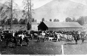
Thursday, May 25. We got as far as Penticton this evening, and I had a good look at the place, but I did not like the look of it, although everyone says it is a very good place for wintering cattle.

Later of course, Ellis was to discover just how good a place it was.

As they left Osoyoos, Ellis watched the territory, seeing few if any spots where he could start a cattle ranch; the area just north of Osoyoos did have a fairly wide valley, but, other than the small river flowing through it, that region was one of extreme aridity. North of that was another, smaller region, boulder-strewn, and if anything, even more arid than the larger valley, with one small creek coming out of a canyon to the east. They passed one lake, and another valley as small as or smaller than the others, then a much larger lake, with nothing but rolling hills, or steep mountains fringing it. Then Haynes slowed a bit and spoke to him.

“The Penticton area is next, so take a good look at it, Tom.” Tom did and wa singularly unimpressed with what he saw. As they left the first of the two lakes they had passed, he saw what appeared to be a larger lake fringed with gray-white cliffs and steep hills or mountains, with a large open expanse between where they were and that lake. There was a river slowly wriggling its way through that expanse, the stream marked by reeds throughout its length, a sure sign of boggy ground. There were creeks all over the place on the eastern side of the open area, with rocks and boulders everywhere among them, and copses of poplars in many places, and pines he first here and there throughout the region. There were open stretches of desert-like gray-green land at the tops of the cliffs. How on earth could a man create a cattle ranch out of a location like this? He did not know the answer, and doubted if anyone else did either.

Ellis Goes to Trail

There are only a few more entries in Ellis’ diary, or what we have been able to find of it, so far. His impressions of the Kootenays, where he spent at least the summer of 1865 and perhaps longer, and then his return to the Okanagan and the reason for his change of mind about Penticton would be interesting, but not vital to this history.

okanagan cattle
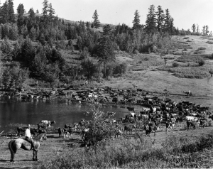
His diary does record that Andy and Ellis planted “…some potatoes, for seed,” at Osoyoos, and his daughter, Dr. Kathleen Ellis told this writer that her father made “…several trips back from where he was working, to tend the potato patch….”

The way those potatoes produced may have been convincing, showing Ellis the extreme fertility of virgin Okanagan soil. Dr. Ellis said that her father worked at a station on the Dewdney Trail, “…near the Columbia River,” and she and I deduced that the site of the present city of Trail was the place. A summer, and perhaps longer, spent there would have introduced Ellis to the importance of mining to British Columbia, and the needs of the mining communities for a supply of quality beef, leading to his later on becoming the source of that supply. Tom Ellis was shrewd enough to see this.

On May 24, 1866, Ellis returned to Penticton, and set up the start of his cattle ranch. Andy may have been with him then, but evidently did not remain for long, which is not surprising. Ellis was serious about starting his cattle ranch. Ellis had the capital for that start, but apparently

Andy didn’t, and didn’t seemingly wish to be tied down to the arduous work needed for a cattle ranch.

Without going into too many details, we know that Ellis took over properties in the Penticton area starting in 1866 and that he later filed on a pre-emption in 1869. That “69” was significant, for it led to Ellis adopting the “69” brand, which is the same either way up, and would thus appeal to the young Irishman. Other than the heifers he bought at Osoyoos, we haven’t the slightest idea where the rest of his cattle came from. The guess is that he may have got some from Richter, or else through Haynes at Osoyoos that is not particularly important, what is, is that he got them and speedily set up the basis of his ranch. What was Penticton like in those early days? That’s a story for another day.

THE LEGEND OF THE MASSACRE OF THE LOST CONQUISTADORS

in Keremeos/Similkameen by

There is evidence that a Spanish expedition from a Pacific coast port in Mexico reached the mouth of the Columbia River in 1775. Bruno Heceta and Juan Francisco de la Bodega y Quadra sailed their ships, Santiago and Sonora, close to the Columbia delta to take on supplies, as the crews were suffering from scurvy and needed a change in diet. They were set upon by the Chinookan people of the Columbia Basin and losses were considerable. A few escaped into the thick forest. This is the probable origin of the lost patrol.

Thinking that CONQUISTADOR 2
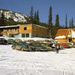
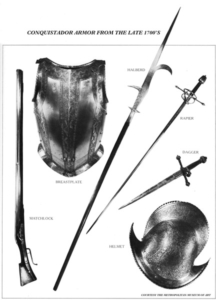
the Columbia River was actually a bay, the conquistadors traveled upstream hoping to find a crossing away from the marauding Chinookans. But the river was very wide and went on forever. These men were seasoned soldiers with amazing survival skills who carried their faith in God as an additional sword. Without horses they would have made no more that 10 or 15 miles a day along the banks of the Columbia. Coming through the deep gorge of the Cascade Mountains, it would have taken months to just make it as far as The Dalles. From there the river got calm and the small tributaries were easy to cross. The land stretched out and became desert like. The local natives were friendlier but cautious of these dark, hairy travellers with metal weapons. The soldiers would have traded for pack dogs with the Chelan people as the Spanish had skills with pack animals of all kinds. Horses would not be seen in this northland for another 50 years.

Then they reached the mouth of the Okanogan River and were told to turn north. Looking at the sands of the Okanogan River they may have seen gold flakes, sparking some excitement of the rumour of a golden city. They turned north.

The Similkameen legend states that sometime near the start of the 1800s, a band of men with white faces and muconquistador 1ch hair and wearing “metal” clothes, marched into the valley from the south and camped near the Keremeos Indian village at Cawston Creek. They remained there until an altercatio
n erupted between a Similkameen man and a soldier over trading for women. The quarrel quickly escalated into a bloody battle. The heavily armed Spanish professional soldiers; inflicted heavy losses on the natives. In a barrage of stones and spears, the Conquistadors, along with several captives, retreated up the valley of Keremeos Creek.

Continuing up that stream, the legend states, the Spaniards crossed over the divide and marched down the Shingle Creek draw. At the foot of Okanagan Lake they crossed through the wetland near Snpintktn (Penticton) to the eastern side and followed the old eastside Indian trail to Nxokostan and established a camp close to a little creek a few miles north of the present day site of Kelowna. There it is speculated, they threw up a large log building to winter with their captives.

The following spring, with their numbers dwindling from either disease or hostility, they left their outpost and retraced their steps southward. The column with numbers considerably reduced, made their appearance once again near the upper reaches of Keremeos Creek.

Several days later, so the story goes, they marched out of the hills and camped on a small flat overlooking Keremeos Creek; evidently close to the area where the stream enters the valley (where the cemetery is today). Forewarned, the Similkameens kept close watch on the column
and when the Spaniards struck camp and moved off down the valley; they were ambushed and overwhelmed by a large number of Similkameens. A vicious battle took place in which the outnumbered Spaniards were annihilated.

According to the legend, the Similkameens then buried the despised white strangers with all their armor and weapons in a low, grassy mound somewhere between the last Spanish camping place and the Indian village called Keremye’us, and there, so the band Elders swear, they remain to this day.

There is some evidence that tends to corroborate the story:
Bits of old steel weapons have been recovered in various parts of the valley and especially in the area close to Keremeos. They may have been trade items from later expeditions into the Similkameen area but why were they concentrated almost exclusively around Keremeos? One such metal artefact is on display in the Penticton Museum today.

The pictographs in the valley also provide other clues, especially the “Prisoner Painting” which seems to depict four Indian warriors roped or chained together and surrounded by dogs. Isn’t it a common Spanish custom to chain their captives together and guard them with dogs? It’s an interesting theory.

Print
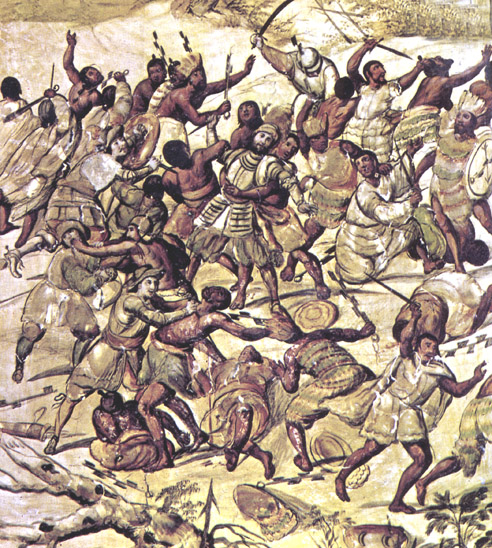
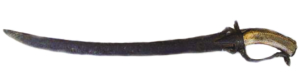
The discovery of a rare native breastplate; hammered from copper, in an old burial site near Keremeos, also lends credence to the Spanish story. The piece is heavily perforated to look like chain mail. Where did the Similkameen Band get the idea of armor plate? It was singular to the Keremeos region and some historians contend that the Indians simply copied the Spanish mail they had seen or been told of, which had proven nearly impenetrable to arrows during the battles.

Spanish prisoners Finally, in 1863, the ruins of a large building were discovered in the Kelowna area. The size of this massive structure, estimated at around 35’ by 75’ indicated that it had once been a winter quarters and even in 1863 was very old. Was this a building used by local peoples for ceremonial purposes or was it the place the legend says was used by the Spanish when they purportedly wintered near Kelowna?

The clues are fascinating but by no means conclusive and the mystery of the “Spanish Mound” remains in legend.

© 2012 by Brian Wilson

THE QUEST TO COMPLETE THE HOPE – PRINCETON HIGHWAY

in Hope/Similkameen by

Historians say the Hope-Princeton Highway took 103 years to complete. Was it really started in 1846? The answer is yes.

The names are in our earliest recorded history of European visitors. Gold and furs were the driving force into the interior and it was the Hudson’s Bay Company that first requested an expedition. Alexander Anderson and 5 others followed Native trails and were the first to see the Okanagan. John Fall Allison was asked by Governor Douglas to find an easier route from Hope inland in 1858. His Brother-in-law, Edgar Dewdney followed his trail to Tulameen in 1861, using Royal Eng
ineer Sappers to build a narrow road.

The road always came up with subsequent governments, but it just couldn’t be finished. The road went as far as Sunshine Valley from Hope and up to Copper Creek from Princeton. Wars and Depressions came and went and still no through road.

HPMP 019A copy
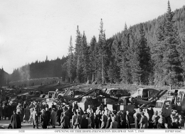
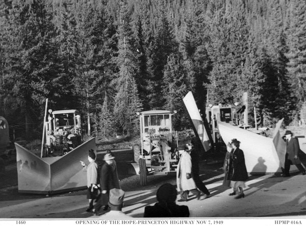
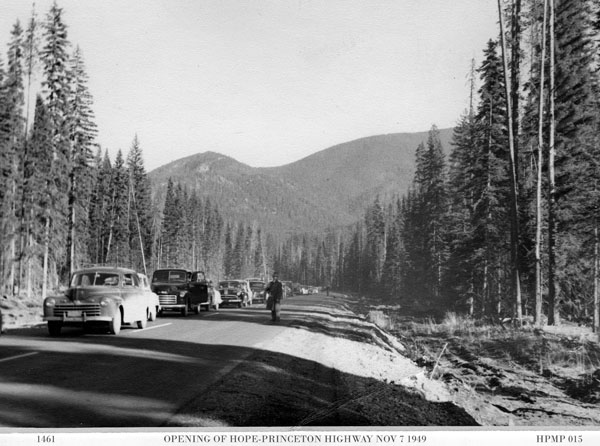
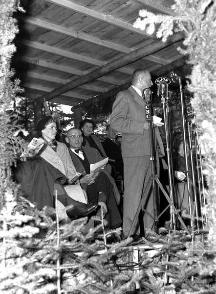
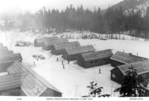
At the height of the depression, the Federal Government provided funds for construction of the road and the Province put into effect a work relief program. 40 relief camps were set along the route and workers came from all over Canada. These men worked year round in camp shacks where snow drifted in and hygiene was rare. But they did get fed regularly and could send money home to their families. Some never
left the area and made their homes in Princeton working for the mines.

In 1937, the Interior Board of Trade, with delegates from every walk of life, walked from Princeton to Hope with much fan-fare. Accompanied by press corps and Politicians, they protested the inaction of both Victoria and Ottawa in completing the road. Then War was declared. There was a terrible injustice in 1941, that  ended  up  helping  the construction of the highway – The internment of Japanese Canadians.

An internment camp was set up at each end of the highway, one near Hope, the other n
ear Princeton. Now there was no shortage of cheap labour during the war years.

In 1943, another group calling themselves the “Caravan of Hope” gathered at Princeton. Around a hundred souls left early on Labour Day for the backwoods of Cambie Flats and on to Allison Lake. The road ended there and the trek to Skagit Bluffs was a good 10 miles off. Cars met them at the bluffs where workers were attempting to blast and scale the cliffs for a roadway. They arrived in Hope before 4pm.HPMP 067 copy

The War was coming to an end when the B.C. Government made the ultimate commitment to the completion of Highway #3. In 1945,  the  construction  contract  was  let to  J. Tomlinson and E. Anderson. Work began in earnest that year and four years later, at a cost of $12,000,000, the route was completed.

Premier Byron Johnson

The cost was nearly $90,000 per mile from Hope to Kaleden, a total of 134 miles.

An opening ceremony was held November 2nd, 1949; with Premier Byron Johnson opening the gate at Allison Pass. Officiating were E.C. Carson, Minister of Public Works, and Herbert Anscomb, Minister of Finance.
Over 1000 bystanders waited many hours in the frosty weather to be the first to drive over the twisting road. Delegations from all principal communities rushed to speak with Politicians in the hope that Tourism money could be forthcoming with the rush of visitors to their towns and villages.

Just 5 hours after the ceremony, a car went off the road on the hill near

Penticton Mayor Lyons rt with Chamber delegate

Sunshine Valley and 5 people were critically injured and 3 died of their injuries. They were the first in a long line of those who lost their lives on the winding road. I recall the Kettle Valley
Railway never lost a passenger in 50 years of operation.

Over 300 visitors arrived in Penticton that night and there was nowhere to stay. They say it was the start of something good.

RELATED ARTICLE – THE HOPE-PRINCETON GALLOWS

HPMP 027A copy
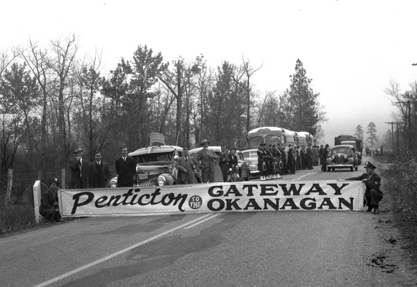
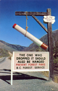
There is confusion about the history of this sign. Here’s the true story.

The “Big Burn” was first reported on August 8th, 1945 by a Canadian Pacific Airline pilot who saw it from his flight path. The smoke was so heavy that a Kamloops Forestry lookout spotted it at about the same time as a U.S. Forest Service tower in the Cascades called it in.

The story of the cigarette is not altogether true. Actually, the true cause of the fire was a slash burn that got away from workers building the Hope-Princeton Highway. Because of the rough terrain between the Allison hill and the Skagit Bluffs, it was not until August 11th that 140 men were able to reach the centre of the fire zone.The Forest Service took advantage of the Japanese camp at Tashme and pressed the internees to work the fire. That brought the force to well over 200 men. The fire was attacked for 11 days before bringing it under some kind of control. It wasn’t until August 26th during a long rain storm that it was declared “out”. By then the fire had devastated 5,920 acres of prime timber. The scar remained for many years.

The gallows wasn’t erected until well after the Hope-Princeton was officially opened in 1949. Funny thing about the sign is that it was at the start of the B.C. Forest Service forest fire prevention program. The U.S. had launched it’s Smokey Bear program at this time and the Bear quickly became a household symbol.

Canadians couldn’t make up their mind as to a symbol…who wanted Benny the Beaver preventing forest fires? So the gallows went up to the horror of some who travelled the road. The cigarette was the symbol of devastation even though the ravaged area was not caused by the butt. It wasn’t until 1956 that the Canadian Forestry Association bought rights to Smokey. We’ve shared it ever since.

When capital punishment ended in Canada in 1962, the gallows became inappropriate and was taken down.

1 3 4 5
Go to Top